|
June 1993
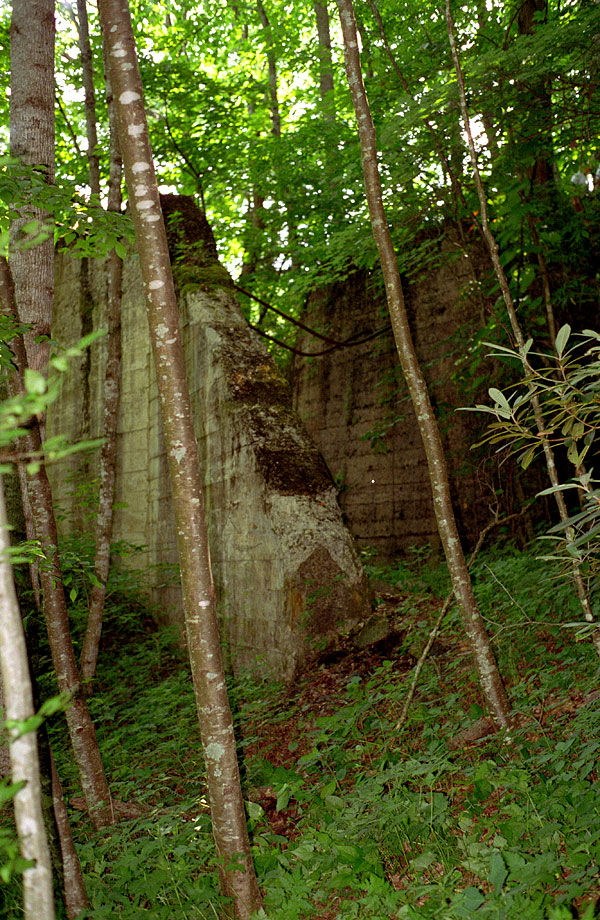
Greer Fill Abutments
Ok, another long, historical, diatribe. And I'll warn you, it's not the last one. This is the site of Greer Fill on the way
up State Line Hill into Elk Park. Hwy. 19E is on the other side
of this site, so we are looking north. This fill was
a trestle when built and was then filled. It was large at about 400
feet long, and very high, although it's not over a river, there is a small amount of constant running
water underneath it. The Wilder Iron Mine is behind us here about
a half mile. The mine was the reason for this structure which
was simply an overpass for a truck road. The trucks used to haul from the mine passed underneath the tracks between these abutments. The abutment on
the right was the eastern end of the fill. The abutment on the
left actually held back the fill from the truck road. Since the
fill is gone, you can now see the valley as it looked before
the railroad was put in. The fill was taken out in the mid 50s
I'm guessing. Photos of the operation taking the fill away looked like a gravel crushing operation. Anyway, the abutments
here are about 12 feet apart, about 12 feet high and with the
wing walls, are pretty long, about 30-35 feet. One can today
hike along the old truck road from the highway back to the site
of the Wilder Mine, although I've never gotten to go back to
it myself (it's on my to-do list). This is just a few feet from the
Appalachian Trail, but you could hike by and never see it. You will see lots of people hiking and cars parked
near this spot on the highway.
The thing I thought was so interesting about this
apparently mundane little overpass is the presence of the two,
2-inch steel rods that cross from one abutment to the other.
At first glance they look like they were straight at one time
and got bent somehow when the railroad was abandoned. Not so.
Upon inspection, the two steel rods, the left end being threaded
for large nuts and a holding plate, were cast into the abutments
at that angle, in other words, they were curved when they were
put in. And the bottom of the bend of the rods is not in the
center of the span. That made me wonder why, what
for, how, and all that. I wish someone familiar with bridge
construction would let me know why the rods were bent, possibly
to clear something under the tracks? And why were they not centered?
A short span of about 12 feet would not take much of a bridge,
timber or steel, to do the job. What would they need to be bent
down to clear? There are notches in the abutments where the timber
or steel stringers rested. The threaded end of the rod sticks
up to the level of the track and about 3 feet out from the abutment.
It's obvious from the nuts and the holding plates that this end
of the rods was attached somehow to the trestle that stood there initially. If anyone has any insight into this I would appreciate
hearing from you. Needless to say, this is a must
see spot along the State Line Hill right-of-way, especially when the leaves
are down. "Tweetsie Country" had a photo of this fill taken from the highway,
and the Stemwinder ran a story with photos about it several years
ago. It was the largest fill on the line.
|